
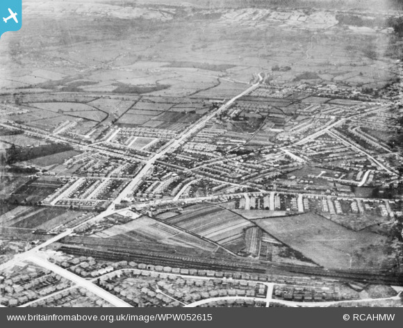
WPW052615 WALES (1937). View believed to show the Whitchurch area of Cardiff. Oblique aerial photograph, 5"x4" BW glass plate.
© Hawlfraint cyfranwyr OpenStreetMap a thrwyddedwyd gan yr OpenStreetMap Foundation. 2024. Trwyddedir y gartograffeg fel CC BY-SA.
Manylion
| Pennawd | [WPW052615] View believed to show the Whitchurch area of Cardiff. Oblique aerial photograph, 5"x4" BW glass plate. |
| Cyfeirnod | WPW052615 |
| Dyddiad | 1937 |
| Dolen | Coflein Archive Item 6423343 |
| Enw lle | |
| Plwyf | |
| Ardal | |
| Gwlad | WALES |
| Dwyreiniad / Gogleddiad | 315540, 180300 |
| Hydred / Lledred | -3.2173117472017, 51.514820729635 |
| Cyfeirnod Grid Cenedlaethol | ST155803 |
Pinnau
Byddwch y cyntaf i ychwanegu sylw at y ddelwedd hon!
Cyfraniadau Grŵp
"Sam" has identified that the image is reversed horizontally. The picture is taken from just south of the (current) Gabalfa interchange pointing north. The road going bottom left to top right is the A469 Caerphilly Road. A really interesting picture - just wish it was available in higher definition. Please re-issue with the correct orientation. |
 Cardiff Steve |
Thursday 13th of November 2014 11:54:53 AM |
This is an image of the Birchgrove area of Cardiff, but for some reason the image has been flipped horizontally. |
Sam |
Thursday 9th of October 2014 09:17:29 PM |


