
WPW029773 WALES (1929). View of Aberdare, oblique aerial view. 5"x4" black and white glass plate negative.

© Hawlfraint cyfranwyr OpenStreetMap a thrwyddedwyd gan yr OpenStreetMap Foundation. 2024. Trwyddedir y gartograffeg fel CC BY-SA.
Delweddau cyfagos (22)
WPW029708

WPW029768

WPW029769

WPW029773

WPW029781

WPW029782

WPW029784

WPW029786

WPW029787

WPW029812

WPW029813

WPW032559

WPW032560

WPW032561

WPW032562

WPW032563

WPW039993

WPW039994

WPW039995

WPW039996

WPW054901

WPW029779

Manylion
| Pennawd | [WPW029773] View of Aberdare, oblique aerial view. 5"x4" black and white glass plate negative. |
| Cyfeirnod | WPW029773 |
| Dyddiad | 1929 |
| Dolen | Coflein Archive Item 6370638 |
| Enw lle | |
| Plwyf | |
| Ardal | |
| Gwlad | WALES |
| Dwyreiniad / Gogleddiad | 300180, 202590 |
| Hydred / Lledred | -3.444973806744, 51.712690668878 |
| Cyfeirnod Grid Cenedlaethol | SO002026 |
Pinnau
 Class31 |
Wednesday 10th of October 2012 11:23:42 PM | |
Class31 |
Wednesday 10th of October 2012 11:20:49 PM | |
Class31 |
Wednesday 10th of October 2012 11:19:06 PM | |
Class31 |
Wednesday 10th of October 2012 11:17:36 PM | |
Class31 |
Wednesday 10th of October 2012 11:14:21 PM | |
Class31 |
Wednesday 10th of October 2012 11:10:06 PM | |
Class31 |
Wednesday 10th of October 2012 11:09:30 PM | |
Class31 |
Wednesday 10th of October 2012 11:08:33 PM | |
Class31 |
Wednesday 10th of October 2012 11:06:34 PM | |
Class31 |
Wednesday 10th of October 2012 11:05:42 PM | |
Class31 |
Wednesday 10th of October 2012 11:05:13 PM | |
Class31 |
Wednesday 10th of October 2012 11:04:29 PM | |
Class31 |
Wednesday 10th of October 2012 11:03:47 PM | |
Class31 |
Wednesday 10th of October 2012 11:03:13 PM | |
Class31 |
Wednesday 10th of October 2012 11:02:24 PM | |
Class31 |
Wednesday 10th of October 2012 11:00:02 PM | |
Class31 |
Wednesday 10th of October 2012 10:58:30 PM | |
Class31 |
Wednesday 10th of October 2012 10:56:35 PM | |
Class31 |
Wednesday 10th of October 2012 10:55:51 PM |
Cyfraniadau Grŵp
 An aerial view of Port Talbot, 09/10/2013 courtesy of Con Shields |
Class31 |
Thursday 30th of April 2015 05:51:45 PM |
 Skyline view looking east from Neath-Port Talbot Hospital 22/08/2013 |
Class31 |
Monday 26th of August 2013 07:59:33 PM |
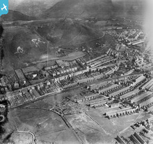 This is a photograph of the Aberavon area of Port Talbot and not Aberdare as officially identified. |
Class31 |
Wednesday 10th of October 2012 11:39:02 PM |
This is not Aberdare. This is part of Port Talbot looking east. The location needs to be ameded. The photographs on each side of this one are of Aberavon and this location could be described as Aberavon. Aberdare to Aberavon is 25 miles distance. |
Class31 |
Wednesday 10th of October 2012 11:36:32 PM |
Aberavon Aberafan GWR railway |
Class31 |
Wednesday 10th of October 2012 11:30:17 PM |
This is not at the grid reference shown but I have no positive identification. Perhaps it should be added to the unidentified shots. |
Class31 |
Tuesday 10th of July 2012 02:53:37 PM |


