
SPW056740 SCOTLAND (1938). Kirkintilloch, general view, showing Forth and Clyde Canal and Kilsyth Road. An oblique aerial photograph taken facing south-west.

© Hawlfraint cyfranwyr OpenStreetMap a thrwyddedwyd gan yr OpenStreetMap Foundation. 2024. Trwyddedir y gartograffeg fel CC BY-SA.
Manylion
| Pennawd | [SPW056740] Kirkintilloch, general view, showing Forth and Clyde Canal and Kilsyth Road. An oblique aerial photograph taken facing south-west. |
| Cyfeirnod | SPW056740 |
| Dyddiad | 1938 |
| Dolen | Canmore Collection item 1258195 |
| Enw lle | |
| Plwyf | KIRKINTILLOCH (STRATHKELVIN) |
| Ardal | STRATHKELVIN |
| Gwlad | SCOTLAND |
| Dwyreiniad / Gogleddiad | 266853, 674914 |
| Hydred / Lledred | -4.132440682715, 55.948824542685 |
| Cyfeirnod Grid Cenedlaethol | NS669749 |
Pinnau
 Bill Craik |
Thursday 25th of June 2015 05:51:00 PM | |
Bill Craik |
Thursday 25th of June 2015 05:47:08 PM | |
Bill Craik |
Thursday 25th of June 2015 05:42:55 PM | |
John Mitchell |
Thursday 23rd of October 2014 12:58:20 PM |
Cyfraniadau Grŵp
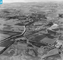 An aerial view of the Forth & Clyde canal, which runs from the River Carron near Grangemouth in the East (where it connects to the Firth of Forth) to the Clyde at Bowling in the West. The canal is connected to the Union canal (connecting Falkirk to Edinburgh) by the innovative rotating lift of the Falkirk Wheel. |
AlMu |
Friday 7th of December 2012 12:05:07 PM |


