
SAW052296 SCOTLAND (1953) [Unlocated]. Unlocated farmland, possibly near Aberdeen. Flattened trees. An oblique aerial photograph. This image has been produced from a print.

© Hawlfraint cyfranwyr OpenStreetMap a thrwyddedwyd gan yr OpenStreetMap Foundation. 2024. Trwyddedir y gartograffeg fel CC BY-SA.
Delweddau cyfagos (48)
EPW000143

EPW000667

EPW005260

EPW006389
, 1921")
EPW007181

EPW015853

EPW015854

EPW015855

EPW016012

EPW016510

EPW016641

EPW017028

EPW017029

EPW017136

SAW003585

SAW003586

SAW009337

SAW009800

SAW009801

SAW009802

SAW010734

SAW014737

SAW017926

SAW017927

SAW032504

SPW020275

SPW020280

SPW020281

SPW020284

SPW020632

SPW020633

SPW027083

SPW049776

SPW049777

SPW049779

SPW049783

SPW049791

SPW049798

SPW049801

SPW049827

SPW049828

SPW049831

SPW049832

SPW049834

SPW049948

SPW049949

SPW051009

SPW062638

Manylion
| Pennawd | [SAW052296] Unlocated farmland, possibly near Aberdeen. Flattened trees. An oblique aerial photograph. This image has been produced from a print. |
| Cyfeirnod | SAW052296 |
| Dyddiad | 1953 |
| Dolen | Canmore Collection item 1315350 |
| Enw lle | |
| Plwyf | |
| Ardal | |
| Gwlad | SCOTLAND |
| Dwyreiniad / Gogleddiad | 0, 0 |
| Hydred / Lledred | -7.556448482059, 49.766185796754 |
| Cyfeirnod Grid Cenedlaethol | SV000000 |
Pinnau
 Class31 |
Wednesday 22nd of January 2014 10:39:36 PM |
Cyfraniadau Grŵp
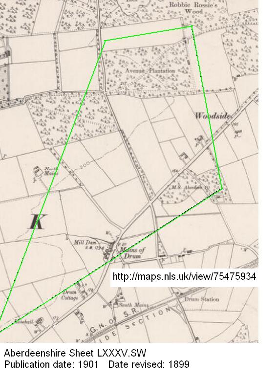 I agree it is Avenue Plantation, looking south towards Mains of Drum from above Robbie Rossie's Wood. Field boundaries etc from http://maps.nls.uk/view/75475934 match. The aftermath of the "devastating storm in Jan 1953 that wiped out most of the medium and older aged forests in North East Scotland" is shown in many photos at http://www.forestry-memories.org.uk/list.asp?field=year&crit=1953 |
 slowcoach |
Saturday 29th of March 2014 12:37:59 PM |
Could the flattened trees be the result of the storm of January/February 1953? The storm surge was partly caused by strong northerly winds, which would certainly have been felt in this area, as the surface pressure chart on http://www.metoffice.gov.uk/news/in-depth/1953-east-coast-flood shows. |
Tony D |
Thursday 9th of January 2014 04:31:23 PM |
Flattened trees of Avenue Platation, Mains of Drum, Aberdeenshire. The road in the top-left is the A93. |
impvan |
Thursday 9th of January 2014 03:59:01 PM |
Agreed. View is looking south. It may just be my display, but the default display of this image seems to be too big - I had no idea that there was a road in the shot, until I read the comment and shrank the image! |
Tony D |
Thursday 9th of January 2014 03:59:01 PM |


