
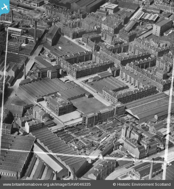
SAW046335 SCOTLAND (1952). Bridgeton, Glasgow, Lanarkshire, Scotland, 1952. An oblique aerial photograph taken facing North/West.
© Hawlfraint cyfranwyr OpenStreetMap a thrwyddedwyd gan yr OpenStreetMap Foundation. 2024. Trwyddedir y gartograffeg fel CC BY-SA.
Delweddau cyfagos (18)
SAW046328

SAW046329

SAW046330

SAW046331

SAW046332

SAW046333

SAW046334

SAW046335

SAW046336

SAW016953

SAW016955

SAW016956

SAW016957

SAW016958

SAW016959

SAW016960

SAW016961

SAW016954

Manylion
| Pennawd | [SAW046335] Bridgeton, Glasgow, Lanarkshire, Scotland, 1952. An oblique aerial photograph taken facing North/West. |
| Cyfeirnod | SAW046335 |
| Dyddiad | 1952 |
| Dolen | Canmore Collection item 1437664 |
| Enw lle | |
| Plwyf | GLASGOW (CITY OF GLASGOW) |
| Ardal | CITY OF GLASGOW |
| Gwlad | SCOTLAND |
| Dwyreiniad / Gogleddiad | 261080, 663690 |
| Hydred / Lledred | -4.2190598458314, 55.846408803278 |
| Cyfeirnod Grid Cenedlaethol | NS611637 |
Pinnau
 redmist |
Thursday 14th of January 2021 04:14:02 PM | |
donna robertson |
Friday 21st of August 2020 04:39:20 PM | |
John Wass |
Sunday 31st of May 2015 09:45:38 PM |


