
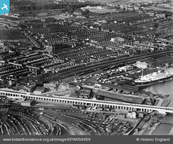
EPW059456 ENGLAND (1938). Silvertown Way, Victoria Dock Road and the surrounding residential area, Canning Town, 1938
© Hawlfraint cyfranwyr OpenStreetMap a thrwyddedwyd gan yr OpenStreetMap Foundation. 2024. Trwyddedir y gartograffeg fel CC BY-SA.
Delweddau cyfagos (5)
EPW059456

EAW008821

EAW008816

EAW008820

EAW009064

Manylion
| Pennawd | [EPW059456] Silvertown Way, Victoria Dock Road and the surrounding residential area, Canning Town, 1938 |
| Cyfeirnod | EPW059456 |
| Dyddiad | 15-September-1938 |
| Dolen | |
| Enw lle | CANNING TOWN |
| Plwyf | |
| Ardal | |
| Gwlad | ENGLAND |
| Dwyreiniad / Gogleddiad | 540184, 180881 |
| Hydred / Lledred | 0.020255731475434, 51.508962924301 |
| Cyfeirnod Grid Cenedlaethol | TQ402809 |
Pinnau
 Del |
Saturday 9th of May 2020 06:34:21 PM | |
Del |
Saturday 9th of May 2020 06:30:16 PM | |
Del |
Saturday 9th of May 2020 06:23:20 PM | |
Del |
Saturday 9th of May 2020 06:21:30 PM | |
Del |
Saturday 9th of May 2020 06:18:25 PM | |
Biff |
Saturday 1st of June 2019 06:59:11 PM | |
Biff |
Saturday 1st of June 2019 06:58:33 PM |
Cyfraniadau Grŵp
.jpg) 2013 view from cable car "Emirates Air Line" |
MikeBellew |
Monday 17th of June 2013 12:03:29 PM |


