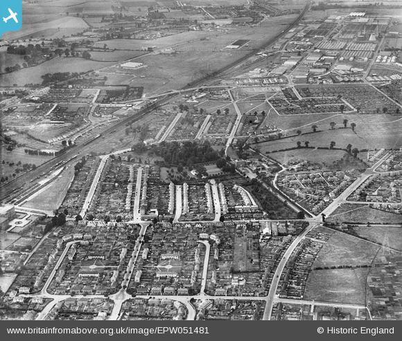
EPW051481 ENGLAND (1936). Housing development around Baylis House and environs, Slough, 1936

© Hawlfraint cyfranwyr OpenStreetMap a thrwyddedwyd gan yr OpenStreetMap Foundation. 2024. Trwyddedir y gartograffeg fel CC BY-SA.

Delweddau cyfagos (2)

EPW051481
  0° 0m
EPW051482
  203° 97m

Manylion

Pennawd [EPW051481] Housing development around Baylis House and environs, Slough, 1936
Cyfeirnod EPW051481
Dyddiad August-1936
Dolen
Enw lle SLOUGH
Plwyf
Ardal
Gwlad ENGLAND
Dwyreiniad / Gogleddiad 496909, 180774
Hydred / Lledred -0.6031856410388, 51.51708315611
Cyfeirnod Grid Cenedlaethol SU969808

Pinnau

Site of small chapel where the service and the notice outside were in Welsh. A lot of welsh people, including my parents, migrated down to Slough between the wars looking for work. It is now the site of an Islamic Centre.

Mike Holder
Thursday 1st of February 2018 06:01:52 PM
Twinches Lane

nikksie
Wednesday 2nd of March 2016 03:49:41 PM
The A4 Bath Road

nikksie
Wednesday 2nd of March 2016 03:46:37 PM
Cippenham Lane

nikksie
Wednesday 2nd of March 2016 03:45:55 PM

nikksie
Wednesday 2nd of March 2016 03:43:17 PM

nikksie
Wednesday 2nd of March 2016 03:43:12 PM
Belgrave Road looking west. Photograph taken today.

Class31
Tuesday 16th of July 2013 10:45:05 PM
Gilliat Road looking south. Photograph taken today.

Class31
Tuesday 16th of July 2013 10:43:09 PM
Parade of shops at junction of Stoke Poges Lane and Bradley Road, Slough . Photograph looking north west, taken today.

Class31
Tuesday 16th of July 2013 10:39:12 PM
Was Satchwell.

payitforwardeddie
Wednesday 29th of May 2013 06:06:53 AM
Farnham Road, bridge over GWR.

payitforwardeddie
Wednesday 29th of May 2013 06:05:08 AM
Site of Slough Technical High School,(went there '62 to '66) now known as Herschel Grammar.

payitforwardeddie
Wednesday 29th of May 2013 06:03:37 AM
Confectioners - for those kids who had a few pennies, this shop was a great temptation to spend your money on sweets on the way home from school. I think it is still a retail outlet today.

Mike Holder
Saturday 18th of May 2013 12:31:38 PM
Underpass built under the main GWR railway line(Paddington to Reading; this allowed access to the park from the Baylis side.

Mike Holder
Saturday 18th of May 2013 12:25:47 PM
Paddling pool for youngsters - NW end of the park - and a small hut to the west for shelter in case of inclement weather. I think there were swings and slides close to the line of trees to the east of the pool.

Mike Holder
Saturday 18th of May 2013 12:23:18 PM
Baylis Lido - outdoor swimming pool - no longer in existence.

Mike Holder
Thursday 16th of May 2013 06:36:43 PM
This building was used as a school just after WWII. I was 4 years old when I went there. Only one class and then on to Elliman Avenue Primary.

Mike Holder
Thursday 16th of May 2013 06:33:37 PM
In the Fifties, this was the local surgery and Dr Findlay was the head of the practice.

Mike Holder
Thursday 16th of May 2013 06:28:04 PM
Elliman Avenue Primary School. Now a housing estate and rebuilt on the other side of the road. The allotments were at the end of the road and have now been used as the school playing field.

Mike Holder
Thursday 16th of May 2013 06:25:31 PM

Cyfraniadau Grŵp

Stoke Poges Lane looking south from Belgrave Road junction. Photograph taken today.

Class31
Tuesday 16th of July 2013 10:40:48 PM
Baylis Road looking west from the junction with Stoke Poges Lane. Photograph taken today.

Class31
Tuesday 16th of July 2013 10:34:55 PM