
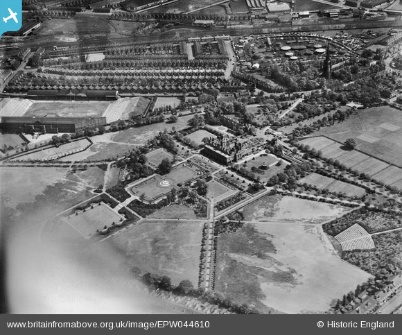
EPW044610 ENGLAND (1934). Aston Hall, Aston Park and surroundings, Aston, 1934. This image has been affected by flare.
© Hawlfraint cyfranwyr OpenStreetMap a thrwyddedwyd gan yr OpenStreetMap Foundation. 2024. Trwyddedir y gartograffeg fel CC BY-SA.
Delweddau cyfagos (9)
EPW044610

EPW044608

EPW044614

EPW044612

EPW044613

EPW044611

EPW044615

EPW044609

EPW044616

Manylion
| Pennawd | [EPW044610] Aston Hall, Aston Park and surroundings, Aston, 1934. This image has been affected by flare. |
| Cyfeirnod | EPW044610 |
| Dyddiad | May-1934 |
| Dolen | |
| Enw lle | ASTON |
| Plwyf | |
| Ardal | |
| Gwlad | ENGLAND |
| Dwyreiniad / Gogleddiad | 407912, 289861 |
| Hydred / Lledred | -1.8834189473237, 52.506221149183 |
| Cyfeirnod Grid Cenedlaethol | SP079899 |
Pinnau
 kevofbrum |
Friday 28th of October 2016 05:18:21 PM | |
kevofbrum |
Friday 28th of October 2016 05:16:07 PM | |
kevofbrum |
Friday 28th of October 2016 05:13:26 PM | |
kevofbrum |
Friday 28th of October 2016 05:12:04 PM | |
kevofbrum |
Friday 28th of October 2016 05:11:36 PM | |
kevofbrum |
Friday 28th of October 2016 05:11:06 PM | |
kevofbrum |
Friday 28th of October 2016 05:10:41 PM | |
kevofbrum |
Friday 28th of October 2016 05:10:13 PM | |
kevofbrum |
Friday 28th of October 2016 05:08:14 PM | |
kevofbrum |
Friday 28th of October 2016 05:07:25 PM | |
kevofbrum |
Friday 28th of October 2016 05:06:50 PM | |
PURCELL |
Saturday 16th of November 2013 08:32:08 PM | |
PURCELL |
Saturday 16th of November 2013 08:31:22 PM | |
iansutherland |
Tuesday 7th of May 2013 12:38:18 PM |


