
EPW042558 ENGLAND (1933) [Unlocated]. UNLOCATED

© Hawlfraint cyfranwyr OpenStreetMap a thrwyddedwyd gan yr OpenStreetMap Foundation. 2024. Trwyddedir y gartograffeg fel CC BY-SA.
Delweddau cyfagos (48)
EPW000143

EPW000667

EPW005260

EPW006389
, 1921")
EPW007181

EPW015853

EPW015854

EPW015855

EPW016012

EPW016510

EPW016641

EPW017028

EPW017029

EPW017136

SAW003585

SAW003586

SAW009337

SAW009800

SAW009801

SAW009802

SAW010734

SAW014737

SAW017926

SAW017927

SAW032504

SPW020275

SPW020280

SPW020281

SPW020284

SPW020632

SPW020633

SPW027083

SPW049776

SPW049777

SPW049779

SPW049783

SPW049791

SPW049798

SPW049801

SPW049827

SPW049828

SPW049831

SPW049832

SPW049834

SPW049948

SPW049949

SPW051009

SPW062638

Manylion
| Pennawd | [EPW042558] UNLOCATED |
| Cyfeirnod | EPW042558 |
| Dyddiad | July-1933 |
| Dolen | |
| Enw lle | |
| Plwyf | |
| Ardal | |
| Gwlad | ENGLAND |
| Dwyreiniad / Gogleddiad | 0, 0 |
| Hydred / Lledred | -7.556448482059, 49.766185796754 |
| Cyfeirnod Grid Cenedlaethol | SV000000 |
Pinnau
 BigglesH |
Thursday 18th of July 2013 03:24:15 AM | |
BigglesH |
Thursday 18th of July 2013 03:21:42 AM | |
BigglesH |
Thursday 18th of July 2013 03:12:46 AM | |
BigglesH |
Thursday 18th of July 2013 03:10:42 AM | |
BigglesH |
Thursday 18th of July 2013 03:08:47 AM | |
BigglesH |
Thursday 18th of July 2013 03:04:50 AM |
Cyfraniadau Grŵp
If you hadn't said the Borders, I would have suspected the House/hospital in Arrow Park, Birkenhead |
BigChes |
Friday 25th of April 2014 11:30:38 PM |
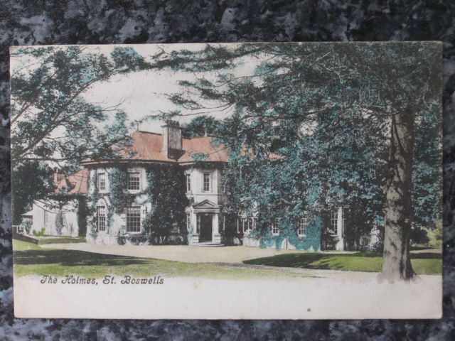
 A photograph of "The Holmes taken September 2012. The Holmes lies between Newtown and St Boswells just to the east of the A68 and to the west of the River Tweed. |
Jim Ross |
Monday 27th of January 2014 11:31:27 AM |
Thanks to everyone who has contributed in identifing this house, we appreciate your hard work. Its lovely to see the other images too. This spot will be forwarded onto our Cataloguing team to verify its location, so the site information can be updated. Many thanks, Liz BfA team |
Liz Fife-Faulkner |
Monday 27th of January 2014 11:31:27 AM |
 Postcard of Holmes |
TomRobin |
Monday 4th of November 2013 06:09:21 PM |
"Think this is a house called The Holmes overlooking the river Tweed." - Martyk identified this house in EPW042559. |
BigglesH |
Thursday 10th of October 2013 08:29:37 PM |
This house also in EPW042559. |
BigglesH |
Thursday 18th of July 2013 03:37:11 AM |
If my assumption about the Front door is correct, I think this photo taken from the East about midday. |
BigglesH |
Thursday 18th of July 2013 03:26:23 AM |
Judging by the steps visible, the house appears to be on top of a hill. |
BigglesH |
Thursday 18th of July 2013 03:20:51 AM |
Subsequent photos (by image reference - EPW042560 & EPW042561) have been identified as Melrose, Scotland. Whether this helps, we shall see! |
BigglesH |
Thursday 18th of July 2013 03:07:55 AM |


