
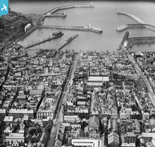
EPW042099 ENGLAND (1933). Whitehaven Harbour, Lowther Street and the town, Whitehaven, 1933

© Hawlfraint cyfranwyr OpenStreetMap a thrwyddedwyd gan yr OpenStreetMap Foundation. 2024. Trwyddedir y gartograffeg fel CC BY-SA.
Delweddau cyfagos (6)
EPW042099

EPW029186

EPW029192

EPW029191

EPW029185

EPW029189

Manylion
| Pennawd | [EPW042099] Whitehaven Harbour, Lowther Street and the town, Whitehaven, 1933 |
| Cyfeirnod | EPW042099 |
| Dyddiad | June-1933 |
| Dolen | |
| Enw lle | WHITEHAVEN |
| Plwyf | |
| Ardal | |
| Gwlad | ENGLAND |
| Dwyreiniad / Gogleddiad | 297365, 518152 |
| Hydred / Lledred | -3.5868965810165, 54.548073866303 |
| Cyfeirnod Grid Cenedlaethol | NX974182 |
Pinnau
 RichardG |
Wednesday 27th of June 2018 05:22:29 PM | |
 Billy Turner |
Wednesday 16th of December 2015 07:11:23 PM | |
 |
Billy Turner |
Wednesday 16th of December 2015 06:31:36 PM |

Cyfraniadau Grŵp
 14 |
MotoFreako64 |
Friday 14th of June 2013 08:52:49 PM |


