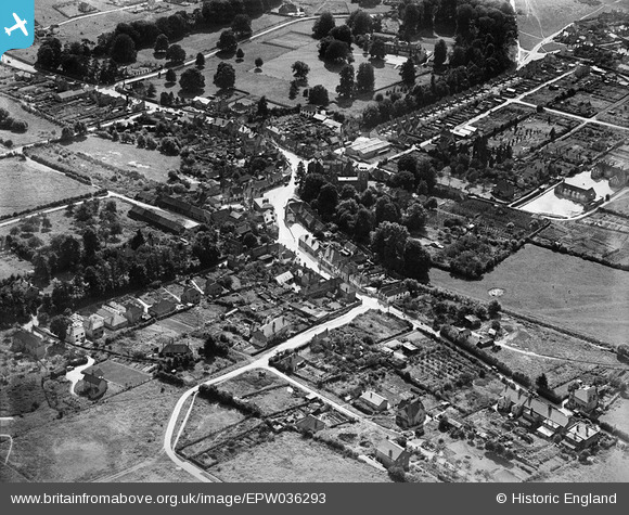
EPW036293 ENGLAND (1931). The town centre, Chalfont St Peter, 1931
© Hawlfraint cyfranwyr OpenStreetMap a thrwyddedwyd gan yr OpenStreetMap Foundation. 2024. Trwyddedir y gartograffeg fel CC BY-SA.
Manylion
| Pennawd | [EPW036293] The town centre, Chalfont St Peter, 1931 |
| Cyfeirnod | EPW036293 |
| Dyddiad | August-1931 |
| Dolen | |
| Enw lle | CHALFONT ST PETER |
| Plwyf | CHALFONT ST. PETER |
| Ardal | |
| Gwlad | ENGLAND |
| Dwyreiniad / Gogleddiad | 500105, 190923 |
| Hydred / Lledred | -0.55424414952847, 51.607760669607 |
| Cyfeirnod Grid Cenedlaethol | TQ001909 |
Pinnau
 jkm |
Wednesday 21st of April 2021 05:58:51 PM | |
 jkm |
Wednesday 21st of April 2021 05:55:52 PM | |
 jkm |
Wednesday 21st of April 2021 05:35:27 PM | |
 jkm |
Wednesday 21st of April 2021 05:34:12 PM | |
 jkm |
Wednesday 21st of April 2021 05:33:27 PM | |
 jkm |
Wednesday 21st of April 2021 05:17:54 PM | |
 jkm |
Wednesday 21st of April 2021 05:15:29 PM | |
 jkm |
Wednesday 21st of April 2021 05:14:25 PM | |
 jkm |
Wednesday 21st of April 2021 05:09:04 PM | |
 jkm |
Wednesday 21st of April 2021 05:05:18 PM | |
Lynda Tubbs |
Tuesday 25th of February 2014 01:06:55 PM | |
Lynda Tubbs |
Wednesday 5th of February 2014 11:49:55 AM |
Cyfraniadau Grŵp
Lynda Tubbs |
Tuesday 25th of February 2014 01:10:52 PM |


![[EPW036293] The town centre, Chalfont St Peter, 1931](http://britainfromabove.org.uk/sites/all/libraries/aerofilms-images/public/100x100/EPW/036/EPW036293.jpg)
![[EPW036296] The town centre, Chalfont St Peter, 1931](http://britainfromabove.org.uk/sites/all/libraries/aerofilms-images/public/100x100/EPW/036/EPW036296.jpg)
![[EPW036295] High Street and the town centre, Chalfont St Peter, 1931](http://britainfromabove.org.uk/sites/all/libraries/aerofilms-images/public/100x100/EPW/036/EPW036295.jpg)
![[EPW036298] St Peter's Church and the town centre, Chalfont St Peter, 1931](http://britainfromabove.org.uk/sites/all/libraries/aerofilms-images/public/100x100/EPW/036/EPW036298.jpg)


