
EPW031209 ENGLAND (1929). The River Thames flood covering South Field, the Eton Railway Viaduct and South Meadow, Eton, 1929

© Hawlfraint cyfranwyr OpenStreetMap a thrwyddedwyd gan yr OpenStreetMap Foundation. 2024. Trwyddedir y gartograffeg fel CC BY-SA.
Delweddau cyfagos (2)
EPW031209

EPW022602

Manylion
| Pennawd | [EPW031209] The River Thames flood covering South Field, the Eton Railway Viaduct and South Meadow, Eton, 1929 |
| Cyfeirnod | EPW031209 |
| Dyddiad | December-1929 |
| Dolen | |
| Enw lle | ETON |
| Plwyf | ETON |
| Ardal | |
| Gwlad | ENGLAND |
| Dwyreiniad / Gogleddiad | 495803, 177564 |
| Hydred / Lledred | -0.619994217261, 51.488414308501 |
| Cyfeirnod Grid Cenedlaethol | SU958776 |
Pinnau
 Ellensdottir |
Sunday 10th of November 2013 04:13:32 PM | |
Ellensdottir |
Sunday 10th of November 2013 04:12:29 PM | |
Ellensdottir |
Sunday 10th of November 2013 04:11:46 PM | |
Ellensdottir |
Sunday 10th of November 2013 04:10:43 PM | |
Ellensdottir |
Sunday 10th of November 2013 04:09:55 PM | |
Ellensdottir |
Sunday 10th of November 2013 04:07:22 PM | |
Ellensdottir |
Sunday 10th of November 2013 04:01:52 PM | |
Ellensdottir |
Sunday 10th of November 2013 03:58:34 PM | |
Ellensdottir |
Sunday 10th of November 2013 03:57:37 PM | |
dave43 |
Tuesday 10th of September 2013 09:36:19 PM | |
flubber |
Tuesday 20th of November 2012 05:27:07 PM |
Cyfraniadau Grŵp
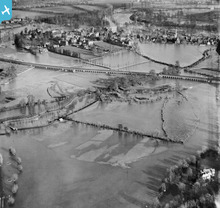 The Eton Railway viaduct carries the Great Western Railway (GWR) past Eton and Eton School in Berkshire. It is clear that Brunel knew that this part of the Thames was prone to flooding when he designed the railway. The viaduct is one of the few structures above the water. |
MM |
Thursday 31st of October 2013 12:56:32 PM |
see sunnymeads wraysbury |
dave43 |
Sunday 28th of October 2012 08:11:51 PM |


