
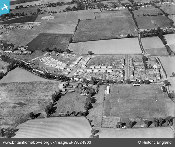
EPW024903 ENGLAND (1928). Ivywall Farm and new housing under construction between Corringham Road and Billet Lane, Stanford-le-Hope, 1928
© Hawlfraint cyfranwyr OpenStreetMap a thrwyddedwyd gan yr OpenStreetMap Foundation. 2024. Trwyddedir y gartograffeg fel CC BY-SA.
Delweddau cyfagos (5)
EPW024903

EPW024900

EPW024905

EAW024610

EAW024611

Manylion
| Pennawd | [EPW024903] Ivywall Farm and new housing under construction between Corringham Road and Billet Lane, Stanford-le-Hope, 1928 |
| Cyfeirnod | EPW024903 |
| Dyddiad | 3-October-1928 |
| Dolen | |
| Enw lle | STANFORD-LE-HOPE |
| Plwyf | |
| Ardal | |
| Gwlad | ENGLAND |
| Dwyreiniad / Gogleddiad | 569363, 182394 |
| Hydred / Lledred | 0.44111941853966, 51.514564069436 |
| Cyfeirnod Grid Cenedlaethol | TQ694824 |
Pinnau
 Ferina |
Tuesday 3rd of July 2012 10:03:53 AM | |
Ferina |
Tuesday 3rd of July 2012 10:03:11 AM | |
Ferina |
Tuesday 3rd of July 2012 10:02:32 AM | |
Ferina |
Tuesday 3rd of July 2012 09:28:25 AM | |
Ferina |
Tuesday 3rd of July 2012 09:25:27 AM |
Cyfraniadau Grŵp
The author Joseph Conrad lived at 'Ivy Walls' from 13th March 1897 to 26th October 1898. See more on Thurrock Council's website at http://www.thurrock.gov.uk/heritage/content.php?page=factfiles_details&id=18 The house was demolished and the 1950's house built was also named 'Ivy Walls'. One of the first occupants were the Phillips family. The adjacent road running north is named Conrad Road. |
Ferina |
Sunday 14th of September 2014 12:29:00 AM |
Ivy walls is were mydad grew up. Im 36 and have only just started to research my dads family history. Really glad i have x |
carla |
Sunday 14th of September 2014 12:29:00 AM |
This photo taken from South-south-west. See also EPW024900 & EPW024905. |
BigglesH |
Thursday 19th of July 2012 05:09:33 AM |
Correction. This photo taken from South-south-east. See also EPW024900 & EPW024905. |
BigglesH |
Thursday 19th of July 2012 05:09:33 AM |


