
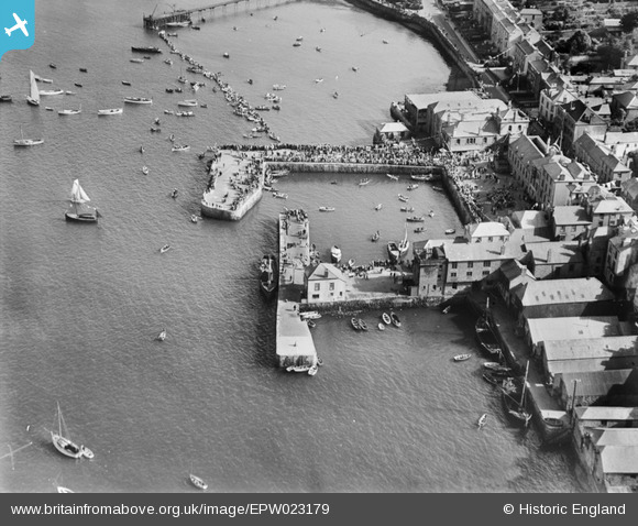
EPW023179 ENGLAND (1928). The Town Quay and North Quay, Falmouth, 1928
© Hawlfraint cyfranwyr OpenStreetMap a thrwyddedwyd gan yr OpenStreetMap Foundation. 2024. Trwyddedir y gartograffeg fel CC BY-SA.
Delweddau cyfagos (14)
EPW023179

EPW023172

EPW023181

EPW023173

EPW023183

EPW023174

EPW023184

EPW023180

EPW023175

EPW023182

EPW023185

EPW023177

EPW023178

EPW021723

Manylion
| Pennawd | [EPW023179] The Town Quay and North Quay, Falmouth, 1928 |
| Cyfeirnod | EPW023179 |
| Dyddiad | 1-September-1928 |
| Dolen | |
| Enw lle | FALMOUTH |
| Plwyf | FALMOUTH |
| Ardal | |
| Gwlad | ENGLAND |
| Dwyreiniad / Gogleddiad | 181124, 32600 |
| Hydred / Lledred | -5.0643132704733, 50.152361028811 |
| Cyfeirnod Grid Cenedlaethol | SW811326 |
Pinnau
 |
 Zawn Haven |
Thursday 3rd of November 2016 10:36:27 PM |
Tony Piper |
Saturday 15th of June 2013 05:38:14 PM | |
Tony Piper |
Saturday 15th of June 2013 05:35:16 PM | |
Tony Piper |
Saturday 15th of June 2013 05:34:05 PM | |
Tony Piper |
Saturday 15th of June 2013 05:33:11 PM |
Cyfraniadau Grŵp
There appears to be some sort of event going on - lots of people on the harbour arm and a line of rowing boats appears to be forming up between the harbour arm and the submarine jetty. |
Brightonboy |
Friday 4th of November 2016 07:59:11 AM |


