
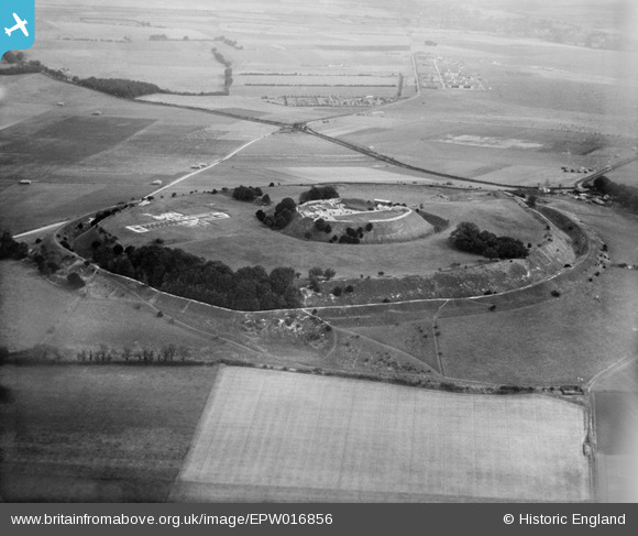
EPW016856 ENGLAND (1926). The hillfort, cathedral and castle, Old Sarum, 1926
© Hawlfraint cyfranwyr OpenStreetMap a thrwyddedwyd gan yr OpenStreetMap Foundation. 2024. Trwyddedir y gartograffeg fel CC BY-SA.
Delweddau cyfagos (10)
EPW016856

EAW005101

EAW018147

EAW018151

EAW018150

EAW018148

EAW005100

EAW018149

EAW005102

EAW005103

Manylion
| Pennawd | [EPW016856] The hillfort, cathedral and castle, Old Sarum, 1926 |
| Cyfeirnod | EPW016856 |
| Dyddiad | August-1926 |
| Dolen | |
| Enw lle | OLD SARUM |
| Plwyf | SALISBURY |
| Ardal | |
| Gwlad | ENGLAND |
| Dwyreiniad / Gogleddiad | 413688, 132639 |
| Hydred / Lledred | -1.8045226007308, 51.092367291407 |
| Cyfeirnod Grid Cenedlaethol | SU137326 |
Pinnau
 Class31 |
Thursday 18th of September 2014 08:15:09 PM | |
Class31 |
Thursday 18th of September 2014 08:10:19 PM | |
David Parry |
Thursday 9th of May 2013 09:16:04 PM | |
Established on land requisitioned by the War Office in 1917 for use by the Royal Flying Corps. |
David Parry |
Thursday 9th of May 2013 09:17:26 PM |
The most complete example of a pre-1919 flying field with associated hangars and workshops in the UK. |
Lynda Tubbs |
Tuesday 7th of January 2014 02:41:17 PM |
David Parry |
Thursday 9th of May 2013 09:02:43 PM | |
Portway, the Roman road coming from the northeast (Silchester). Around 2007 I excavated a section through the Roman road, within land owned by Old Sarum Airfield. You can still see the backfilled evaluation trenches in the Google Maps aerial view (2013). The road was mostly ploughed out, the base of the metalling present and shallow remnants of roadside ditches. |
David Parry |
Thursday 9th of May 2013 09:20:22 PM |
Cyfraniadau Grŵp
 Old Sarum Cathedral, Salisbury, 18/09/2014 |
Class31 |
Thursday 18th of September 2014 08:13:32 PM |
 View towards Old Sarum Airfield from Old Sarum, Salisbury, 18/09/2014 |
Class31 |
Thursday 18th of September 2014 08:12:29 PM |
See also EAW005100 |
 totoro |
Friday 11th of October 2013 01:09:45 PM |
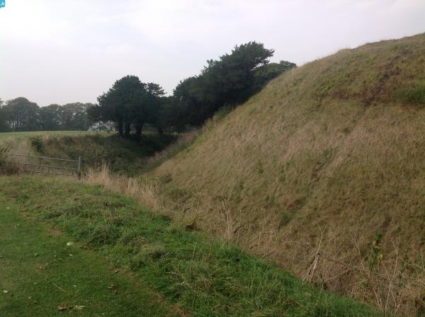
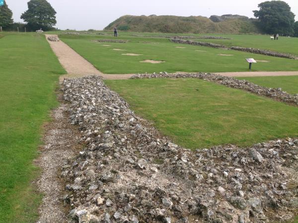
 A multivallate Iron Age hillfort, oval in plan, measuring 580 metres east-west by 460 metres north-south. The earthworks are well preserved and comprise two banks and a medial ditch with two entrances, one on the eastern side which is approached by a causeway and one on the west side which is thought to be medieval in origin. http://bit.ly/O3m9dC |
Brian Wilkinson |
Sunday 10th of March 2013 03:14:55 PM |
That's where I fly from. Have hundreds of images since 2006. We took off in deep snow in 2009 - here's an image. |
Voyeur |
Tuesday 26th of June 2012 07:42:35 PM |
@Voyeur - that's a great image, and I bet on such a snowy day you were glad of an enclosed cockpit! |
Brian Wilkinson |
Wednesday 27th of June 2012 05:01:21 PM |
While working for Wessex Archaeology several years ago, I excavated two sections through the Roman road between Silchester and Old Sarum, just beyond the roundabout on The Protway (top centre of this photo). Part of an evaluation (the backfilled trenches of which are still visible on the Google maps aerial view), we identified the remnants of the road makeup which had survived ploughing and a shallow depth of the roadside ditches. |
David Parry |
Sunday 10th of March 2013 03:14:55 PM |
Another photograph discussed at the get together in Chippenham: stunning Old Sarum. |
Sandra Brauer |
Thursday 29th of November 2012 02:31:57 PM |
Old Sarum airfield is visible in the top right background. Opened in 1917 it was one of the first UK airfields. I believe the hangars visible in the image are still standing as listed buildings. |
pd brambles |
Thursday 16th of August 2012 09:16:43 PM |
Old Sarum |
Robert - Cumbria |
Wednesday 27th of June 2012 05:50:26 PM |


