
EPW015598 ENGLAND (1926). The Neepsend Gas Works, Sheffield, 1926

© Hawlfraint cyfranwyr OpenStreetMap a thrwyddedwyd gan yr OpenStreetMap Foundation. 2024. Trwyddedir y gartograffeg fel CC BY-SA.
Delweddau cyfagos (14)
EPW015598

EPW015494

EPW015488

EPW015484

EPW015493

EPW015597

EPW015486

EAW005032

EAW005029

EAW005028

EAW005031

EAW005030

EPW057400

EAW005033

Manylion
| Pennawd | [EPW015598] The Neepsend Gas Works, Sheffield, 1926 |
| Cyfeirnod | EPW015598 |
| Dyddiad | 4-May-1926 |
| Dolen | |
| Enw lle | SHEFFIELD |
| Plwyf | |
| Ardal | |
| Gwlad | ENGLAND |
| Dwyreiniad / Gogleddiad | 434577, 388843 |
| Hydred / Lledred | -1.4799636176158, 53.395023236828 |
| Cyfeirnod Grid Cenedlaethol | SK346888 |
Pinnau
 Mick.. |
Monday 7th of June 2021 11:31:48 PM | |
neddy |
Wednesday 29th of October 2014 12:36:48 PM | |
Brooky |
Sunday 24th of November 2013 07:58:03 PM | |
Brooky |
Sunday 24th of November 2013 07:54:21 PM | |
Brooky |
Sunday 24th of November 2013 07:40:27 PM | |
 Class31 |
Friday 26th of October 2012 04:13:45 PM | |
Class31 |
Friday 26th of October 2012 04:13:20 PM | |
Class31 |
Friday 26th of October 2012 04:12:52 PM | |
Class31 |
Friday 26th of October 2012 04:12:33 PM | |
Class31 |
Friday 26th of October 2012 04:12:05 PM | |
Class31 |
Friday 26th of October 2012 04:11:39 PM | |
Class31 |
Friday 26th of October 2012 04:11:24 PM | |
Class31 |
Friday 26th of October 2012 04:11:00 PM | |
Class31 |
Friday 26th of October 2012 04:10:31 PM | |
Class31 |
Friday 26th of October 2012 04:09:58 PM | |
Packhorse or Steelbank Weir |
DCRT Karen |
Thursday 4th of August 2016 10:06:56 AM |
Class31 |
Friday 26th of October 2012 04:09:39 PM |
Cyfraniadau Grŵp
I was born at 27 Parkwood Road shown on this photo and lived there till 1934.My grandparents lived at no.15 and aunt at no 32.On the 13th Dec.1940 in the Sheffield Blitz, all the even nos were totally gutted by fire bombs dropped to light up the target followed by a landmine on No 15 which wiped out half the street leaving the last half to be pulled down later. The good news is that in 2009 an action committee was formed to develop the whole of Parkwood as a country park as big as the city centre just a mile or two away. Ron Spencer |
balbus |
Monday 13th of January 2014 07:59:51 PM |
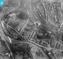 Gasometers like these were a common feature of the landscape. They originally held manufactured town gas and later natural gas. Gas was used to light and then power industrial buildings and homes from the 1820s. |
MM |
Thursday 21st of March 2013 10:31:26 AM |


