
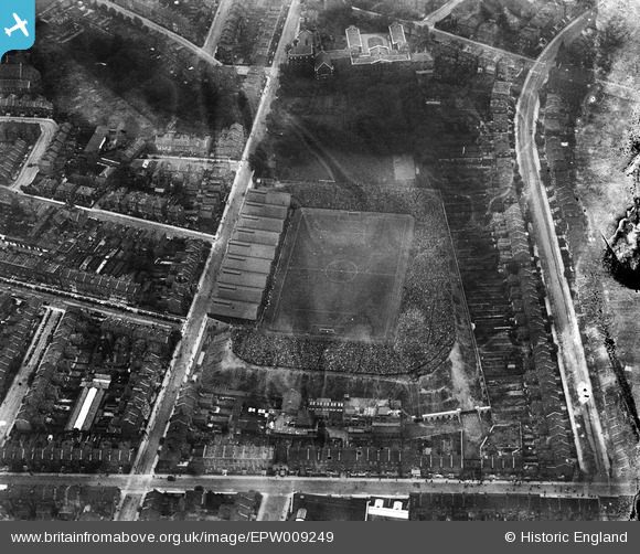
EPW009249 ENGLAND (1923). Arsenal Football Club, Highbury Ground, Highbury, 1923
© Hawlfraint cyfranwyr OpenStreetMap a thrwyddedwyd gan yr OpenStreetMap Foundation. 2024. Trwyddedir y gartograffeg fel CC BY-SA.
Delweddau cyfagos (13)
EPW009249

EPW009248

EPW025837

EPW025838

EPW025836

EPW025835

EPW025834

EAW021413
, Highbury, 1949. This image has been produced from a print.")
EPW009247

EAW021414
, Highbury, 1949. This image has been produced from a print.")
EAW021416
, Highbury, 1949. This image has been produced from a copy-negative.")
EAW021415
, Highbury, 1949. This image has been produced from a print.")
EAW021417
 and environs, Highbury, 1949. This image has been produced from a print.")
Manylion
| Pennawd | [EPW009249] Arsenal Football Club, Highbury Ground, Highbury, 1923 |
| Cyfeirnod | EPW009249 |
| Dyddiad | 1923 |
| Dolen | |
| Enw lle | HIGHBURY |
| Plwyf | |
| Ardal | |
| Gwlad | ENGLAND |
| Dwyreiniad / Gogleddiad | 531624, 186011 |
| Hydred / Lledred | -0.10111314842379, 51.557128092097 |
| Cyfeirnod Grid Cenedlaethol | TQ316860 |
Pinnau
 Tim |
Tuesday 8th of September 2020 03:09:16 PM | |
Merlin1993 |
Friday 25th of July 2014 10:19:02 AM | |
billyfern |
Saturday 28th of June 2014 11:20:31 PM | |
billyfern |
Saturday 28th of June 2014 09:05:36 PM | |
billyfern |
Saturday 28th of June 2014 09:05:15 PM | |
billyfern |
Saturday 28th of June 2014 09:04:38 PM | |
billyfern |
Saturday 28th of June 2014 09:04:20 PM | |
billyfern |
Saturday 28th of June 2014 09:04:06 PM | |
billyfern |
Saturday 28th of June 2014 09:03:51 PM | |
billyfern |
Saturday 28th of June 2014 09:03:25 PM | |
billyfern |
Saturday 28th of June 2014 09:02:41 PM | |
billyfern |
Saturday 28th of June 2014 09:02:22 PM | |
billyfern |
Saturday 28th of June 2014 09:02:03 PM | |
billyfern |
Saturday 28th of June 2014 09:01:43 PM | |
billyfern |
Saturday 28th of June 2014 09:01:15 PM | |
billyfern |
Saturday 28th of June 2014 09:00:34 PM |


