
EPW004060 ENGLAND (1920). General view over the town, Barrow-in-Furness, from the south-east, 1920

© Hawlfraint cyfranwyr OpenStreetMap a thrwyddedwyd gan yr OpenStreetMap Foundation. 2024. Trwyddedir y gartograffeg fel CC BY-SA.
Delweddau cyfagos (2)
EPW004060

EPW004061

Manylion
| Pennawd | [EPW004060] General view over the town, Barrow-in-Furness, from the south-east, 1920 |
| Cyfeirnod | EPW004060 |
| Dyddiad | July-1920 |
| Dolen | |
| Enw lle | BARROW-IN-FURNESS |
| Plwyf | |
| Ardal | |
| Gwlad | ENGLAND |
| Dwyreiniad / Gogleddiad | 319739, 469371 |
| Hydred / Lledred | -3.2279305223878, 54.113764124756 |
| Cyfeirnod Grid Cenedlaethol | SD197694 |
Pinnau
 Westy57 |
Saturday 9th of May 2020 10:37:59 AM | |
steve |
Saturday 10th of November 2012 09:12:44 PM | |
steve |
Saturday 10th of November 2012 09:05:10 PM | |
Neil Loughran |
Monday 17th of September 2012 09:34:33 PM | |
Philip Murray |
Tuesday 28th of August 2012 10:23:01 PM | |
Actually, the rugby ground stands on the site of those reservoirs. The 'old church' is simply some rather fancy windows on the particularly derelict half of the old juteworks. This half of the works became the Corporation bus depot for many years, before redevelopment into shops. |
aiwacat |
Monday 17th of September 2012 11:00:23 PM |
aiwacat |
Sunday 15th of July 2012 12:43:16 AM | |
aiwacat |
Sunday 15th of July 2012 12:42:06 AM | |
steve |
Saturday 14th of July 2012 10:59:21 PM | |
willi |
Saturday 7th of July 2012 11:15:02 PM | |
willi |
Saturday 7th of July 2012 11:13:03 PM | |
willi |
Saturday 7th of July 2012 11:08:14 PM | |
willi |
Saturday 7th of July 2012 11:07:07 PM | |
willi |
Saturday 7th of July 2012 11:04:01 PM |
Cyfraniadau Grŵp
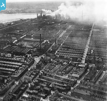 Looking toward iron and steel works |
oversands |
Tuesday 11th of December 2012 05:59:14 PM |
I have tagged an area of the photo (just north west of photo centre) that is land now occupied by Barrow Raiders rugby league ground, Craven Park. I dont know what was on the site prior to the rugby, but there seems to be an old church that stands where now is the west stand of the ground. |
Philip Murray |
Tuesday 28th of August 2012 10:27:40 PM |


