
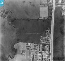
EPW001350 ENGLAND (1920). Hendon Union Workhouse, Burnt Oak, 1920

© Hawlfraint cyfranwyr OpenStreetMap a thrwyddedwyd gan yr OpenStreetMap Foundation. 2024. Trwyddedir y gartograffeg fel CC BY-SA.
Delweddau cyfagos (21)
EPW001350

EPW019191

EPW019193

EPW019190

EPW009345

EPW009346

EPW009347

EPW016519

EPW031549

EPW009344

EPW009363

EPW009682

EPW031548

EPW016517

EPW018766

EPW031583

EPW018769

EPW018768

EPW017584

EPW018772

EPW001352

Manylion
| Pennawd | [EPW001350] Hendon Union Workhouse, Burnt Oak, 1920 |
| Cyfeirnod | EPW001350 |
| Dyddiad | May-1920 |
| Dolen | |
| Enw lle | BURNT OAK |
| Plwyf | |
| Ardal | |
| Gwlad | ENGLAND |
| Dwyreiniad / Gogleddiad | 520124, 190664 |
| Hydred / Lledred | -0.26534140656068, 51.601517239287 |
| Cyfeirnod Grid Cenedlaethol | TQ201907 |
Pinnau
 colsouth111 |
Monday 10th of August 2015 05:16:05 PM | |
colsouth111 |
Monday 10th of August 2015 05:10:38 PM |
Cyfraniadau Grŵp
 Prior to the construction of the tube station and Watling Ave. |
colsouth111 |
Monday 10th of August 2015 05:18:41 PM |


