
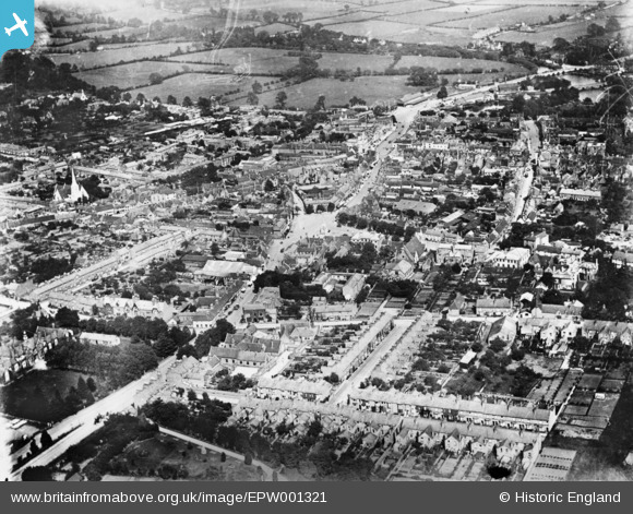
EPW001321 ENGLAND (1920). The town centre, Stratford-upon-Avon, 1920. This image has been produced from a copy-negative.
© Hawlfraint cyfranwyr OpenStreetMap a thrwyddedwyd gan yr OpenStreetMap Foundation. 2024. Trwyddedir y gartograffeg fel CC BY-SA.
Delweddau cyfagos (13)
EPW001321

EPW026843

EAW013458

EPW010588

EPW053208

EPW053204

EAW013455

EPW053209

EPW026841

EAW044238

EPW053210

EAW013457

EPW026842

Manylion
| Pennawd | [EPW001321] The town centre, Stratford-upon-Avon, 1920. This image has been produced from a copy-negative. |
| Cyfeirnod | EPW001321 |
| Dyddiad | May-1920 |
| Dolen | |
| Enw lle | STRATFORD-UPON-AVON |
| Plwyf | STRATFORD-UPON-AVON |
| Ardal | |
| Gwlad | ENGLAND |
| Dwyreiniad / Gogleddiad | 419885, 254994 |
| Hydred / Lledred | -1.7090673919838, 52.192423526272 |
| Cyfeirnod Grid Cenedlaethol | SP199550 |
Pinnau
 tony |
Wednesday 4th of March 2015 03:36:31 PM | |
tony |
Wednesday 4th of March 2015 03:35:43 PM | |
tony |
Wednesday 4th of March 2015 03:35:06 PM | |
tony |
Wednesday 4th of March 2015 03:34:03 PM | |
tony |
Wednesday 4th of March 2015 03:32:33 PM | |
tony |
Wednesday 4th of March 2015 03:31:47 PM | |
tony |
Wednesday 4th of March 2015 03:30:36 PM | |
tony |
Wednesday 4th of March 2015 03:29:44 PM | |
tony |
Wednesday 4th of March 2015 03:28:50 PM | |
tony |
Wednesday 4th of March 2015 03:28:03 PM | |
tony |
Wednesday 4th of March 2015 03:27:07 PM | |
tony |
Wednesday 4th of March 2015 03:26:31 PM |


