
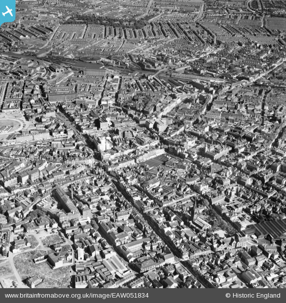
EAW051834 ENGLAND (1953). The city centre around High Street and Humberstone Gate, Leicester, 1953
© Hawlfraint cyfranwyr OpenStreetMap a thrwyddedwyd gan yr OpenStreetMap Foundation. 2024. Trwyddedir y gartograffeg fel CC BY-SA.
Delweddau cyfagos (25)
EAW051834

EPW018412

EAW024242

EPW018422

EPW018431

EAW024244

EAW024243

EAW024239

EAW024240

EPW018436

EPW055011

EPW018433

EPW047643

EPW020892

EPW047645

EPW018421

EPW020895

EPW047641

EPW055006

EPW061211

EAW051831

EPW047868

EPW061213

EPW055002

EPW018435

Manylion
| Pennawd | [EAW051834] The city centre around High Street and Humberstone Gate, Leicester, 1953 |
| Cyfeirnod | EAW051834 |
| Dyddiad | 1-September-1953 |
| Dolen | |
| Enw lle | LEICESTER |
| Plwyf | |
| Ardal | |
| Gwlad | ENGLAND |
| Dwyreiniad / Gogleddiad | 458826, 304522 |
| Hydred / Lledred | -1.1306661818138, 52.634904605701 |
| Cyfeirnod Grid Cenedlaethol | SK588045 |
Pinnau
 Class31 |
Tuesday 5th of May 2015 02:36:05 PM | |
Class31 |
Tuesday 5th of May 2015 02:33:57 PM | |
Class31 |
Tuesday 5th of May 2015 02:26:25 PM | |
 |
Class31 |
Tuesday 5th of May 2015 02:25:40 PM |
Class31 |
Tuesday 5th of May 2015 02:24:58 PM |


Cyfraniadau Grŵp
 Memorial tomb of King Richard III of England, Leicester Cathedral, 04/05/2015 |
Class31 |
Tuesday 5th of May 2015 02:29:13 PM |


