
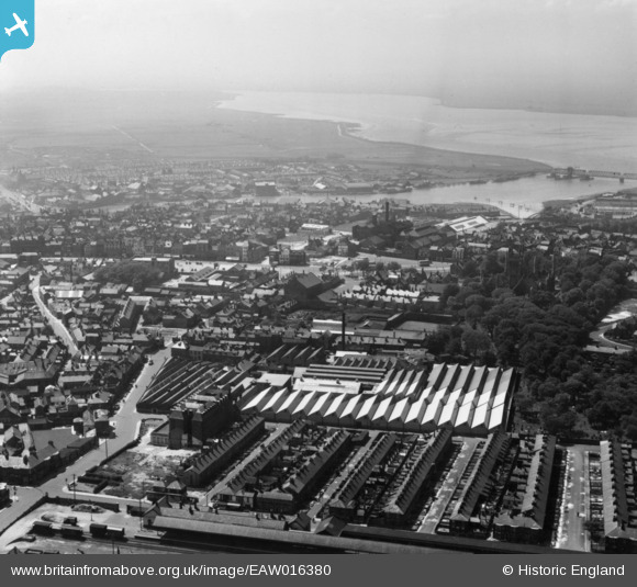
EAW016380 ENGLAND (1948). The Grout and Co Ltd Textile Factory and environs, Great Yarmouth, from the east, 1948. This image has been produced from a print.
© Hawlfraint cyfranwyr OpenStreetMap a thrwyddedwyd gan yr OpenStreetMap Foundation. 2024. Trwyddedir y gartograffeg fel CC BY-SA.
Delweddau cyfagos (28)
EAW016380

EAW016350

EAW016344

EPW021188

EAW016347

EAW016343

EAW052971

EAW052963

EPW008059

EPW008055

EPW008057

EPW008056

EPW008058

EAW052967

EAW052965

EAW052966

EAW052964

EAW052968

EAW052969

EAW052970

EAW016346

EAW016345

EAW016348

EAW016353

EAW016351

EAW016352

EAW016349

EAW016342

Manylion
| Pennawd | [EAW016380] The Grout and Co Ltd Textile Factory and environs, Great Yarmouth, from the east, 1948. This image has been produced from a print. |
| Cyfeirnod | EAW016380 |
| Dyddiad | 9-June-1948 |
| Dolen | |
| Enw lle | GREAT YARMOUTH |
| Plwyf | |
| Ardal | |
| Gwlad | ENGLAND |
| Dwyreiniad / Gogleddiad | 652783, 307986 |
| Hydred / Lledred | 1.7342074481389, 52.610357896541 |
| Cyfeirnod Grid Cenedlaethol | TG528080 |
Pinnau
 redmist |
Tuesday 18th of January 2022 07:52:01 PM | |
 Matt Aldred edob.mattaldred.com |
Sunday 27th of December 2020 03:03:33 PM |


