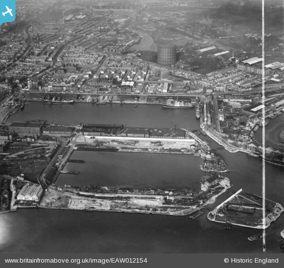
EAW012154 ENGLAND (1947). East India Docks, Blackwall, 1947. This image was marked by Aerofilms Ltd for photo editing.

© Hawlfraint cyfranwyr OpenStreetMap a thrwyddedwyd gan yr OpenStreetMap Foundation. 2024. Trwyddedir y gartograffeg fel CC BY-SA.

Delweddau cyfagos (48)

EAW012154
  0° 0m
EAW013360
  180° 50m
EAW004332
  184° 82m
EPW011938
  215° 91m
EAW013359
  149° 98m
EPW009112
  187° 101m
EPW036253
  63° 102m
EAW008751
  177° 104m
EAW013630
  172° 110m
EAW013365
  144° 111m
EAW013364
  180° 121m
EAW008749
  132° 126m
EAW024919
  187° 136m
EAW024922
  165° 139m
EAW024921
  156° 141m
EAW004325
  149° 145m
EAW024916
  154° 152m
EAW004329
  137° 157m
EAW008752
  116° 158m
EAW013627
  169° 159m
EAW004330
  163° 160m
EPW005311
  87° 167m
EAW008754
  107° 168m
EAW004328
  148° 170m
EAW013628
  156° 172m
EAW008750
  163° 176m
EAW013629
  161° 179m
EAW013624
  180° 183m
EAW024918
  156° 184m
EAW013631
  152° 186m
EAW013625
  129° 196m
EAW053005
  172° 198m
EAW004327
  151° 203m
EAW013634
  123° 204m
EAW013626
  175° 206m
EAW024914
  149° 208m
EAW024917
  146° 211m
EAW024920
  148° 214m
EAW013366
  145° 217m
EAW099748
  274° 220m
EAW012155
  187° 228m
EAW004326
  175° 234m
EAW024915
  150° 237m
EAW013362
  184° 243m
EAW013633
  154° 251m
EAW004331
  152° 257m
EAW013632
  137° 264m
EAW008753
  146° 274m

Manylion

Pennawd [EAW012154] East India Docks, Blackwall, 1947. This image was marked by Aerofilms Ltd for photo editing.
Cyfeirnod EAW012154
Dyddiad 10-November-1947
Dolen
Enw lle BLACKWALL
Plwyf
Ardal
Gwlad ENGLAND
Dwyreiniad / Gogleddiad 538774, 180949
Hydred / Lledred -0.000024271785719776, 51.509922142012
Cyfeirnod Grid Cenedlaethol TQ388809

Pinnau

I have been searching for St Leonards Road School. I believe this is it at the northern extreme of St Leonards Road. Front row seated to the right is my Father. Always told me off for throwing stones as he lost his left eye doing the same trick not far from this spot in Three Mill Lane. Photo is marked on the reverse 1938

Grollo
Monday 20th of April 2015 04:08:18 AM
Culloden Street School

Grollo
Monday 20th of April 2015 04:06:26 AM
Limehouse cut. There is what looks like a timber shed above the pin. There were many along the canals and they used to have a canopy that extended part way over the canal to allow the barges to be worked in the rain.

Grollo
Wednesday 12th of March 2014 04:17:55 PM
St Michael and All Angels Church. Teviot Street to the east and St Leonards Road to the west. The vicarage for the church stand in front. St Leonards Road extended further north and eventually joined Brunswick Road.

Grollo
Wednesday 12th of March 2014 04:14:36 PM

Grollo
Friday 7th of March 2014 04:45:08 PM
Construction of Braithwaite House

Grollo
Friday 7th of March 2014 04:43:57 PM
All Hallows Church and a brief description follows. The church was badly damaged in the Second World War and was demolished in 1952. (ref. 450) A short length of iron railings and the steps down from East India Dock Road survived in 1993. It was thereafter represented by the church of St Nicholas and All Hallows in Aberfeldy Street, opened in 1955 (ref. 451) and by 1990 itself closed. Until recently the site was never developed and was used as a grassed play area for the flats Currie House and Dunkeld House completed in 1954 and now demolished.

Grollo
Friday 7th of March 2014 12:12:45 PM
Below is a possible description of this property. What remained during the 1960's were terraced houses of a larger style. The parish room and mission room eastward of the church were built in 1884–5 to designs by J. D. Sedding (1839–91), (ref. 448) but the vicarage or clergy-house was built west of the church only in 1911 (architects, Heazell & Sons of Nottingham: builder, J. W. Jerram of West Ham, who tendered at £1,975). This was an old-fashioned building with big pitched roof and gablet. Further information on this area can be found at the link below. http://www.british-history.ac.uk/report.aspx?compid=46480&strquery=Tavern#n88

Grollo
Friday 7th of March 2014 12:07:19 PM
Andersons. I believe they may have had a shop in Chrisp Street asI only new this place to be used for storage. Was on the corner of Abbott Road and Oban Street. Think they were some kind of Tallyman.

Grollo
Friday 7th of March 2014 11:44:17 AM
Iron Bridge Tavern public house.

Grollo
Friday 7th of March 2014 11:40:39 AM
Poplar bus garage Athol Street. More information can be found at the link below. http://www.ltsv.com/sv2/locations_detail.php?id=70

Grollo
Friday 7th of March 2014 11:23:37 AM
Poplar bus garage, Leven Road was originally a depot for trolley buses.

Grollo
Friday 7th of March 2014 11:17:28 AM