
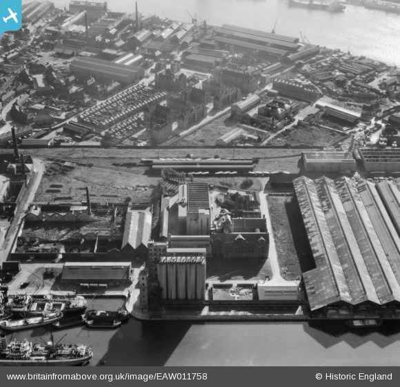
EAW011758 ENGLAND (1947). McDougalls Limited Wheatsheaf Flour Mills, Millwall, 1947
© Hawlfraint cyfranwyr OpenStreetMap a thrwyddedwyd gan yr OpenStreetMap Foundation. 2024. Trwyddedir y gartograffeg fel CC BY-SA.
Delweddau cyfagos (17)
EAW011758

EAW011756

EAW011752

EPW046149

EAW011755

EAW011753

EPW046147

EPW060548

EAW011754

EAW011759

EPW046146

EAW011757

EPW060455

EPW046148

EPW044130

EPW046145

EAW021719

Manylion
| Pennawd | [EAW011758] McDougalls Limited Wheatsheaf Flour Mills, Millwall, 1947 |
| Cyfeirnod | EAW011758 |
| Dyddiad | 9-October-1947 |
| Dolen | |
| Enw lle | MILLWALL |
| Plwyf | |
| Ardal | |
| Gwlad | ENGLAND |
| Dwyreiniad / Gogleddiad | 537548, 178831 |
| Hydred / Lledred | -0.01850760466833, 51.491187245143 |
| Cyfeirnod Grid Cenedlaethol | TQ375788 |
Pinnau
 rivermersey |
Monday 23rd of November 2020 10:58:02 PM | |
rivermersey |
Monday 23rd of November 2020 10:57:00 PM | |
moses72 |
Friday 21st of June 2013 02:03:28 PM | |
moses72 |
Friday 21st of June 2013 02:01:17 PM | |
moses72 |
Wednesday 19th of June 2013 01:45:37 PM | |
bookem1976 |
Monday 4th of March 2013 10:04:57 AM | |
bookem1976 |
Monday 4th of March 2013 10:04:46 AM | |
Andy Johnstone |
Wednesday 4th of July 2012 12:30:29 AM |


