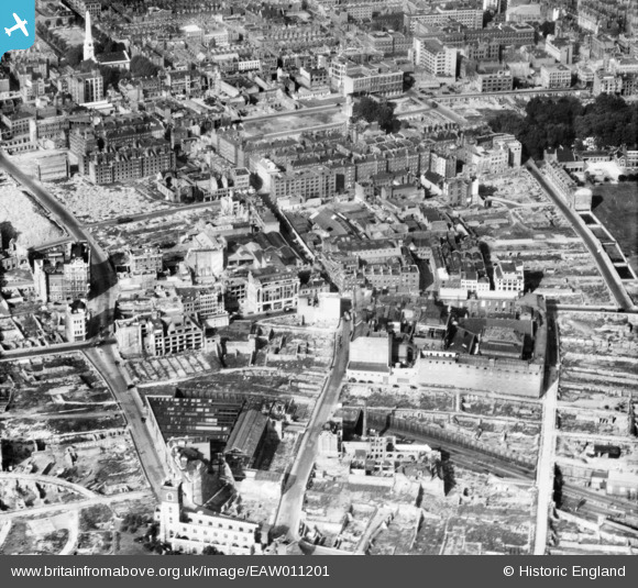
EAW011201 ENGLAND (1947). Cleared areas around the Whitbread Breweries on Whitecross Street following bomb damage, St Luke's, 1947
© Hawlfraint cyfranwyr OpenStreetMap a thrwyddedwyd gan yr OpenStreetMap Foundation. 2024. Trwyddedir y gartograffeg fel CC BY-SA.
Delweddau cyfagos (8)
EAW011201

EAW011117

EAW011367
, London, 1947")
EAW000514

EAW011366

EAW011200

EAW011116

EAW041392

Manylion
| Pennawd | [EAW011201] Cleared areas around the Whitbread Breweries on Whitecross Street following bomb damage, St Luke's, 1947 |
| Cyfeirnod | EAW011201 |
| Dyddiad | 30-September-1947 |
| Dolen | |
| Enw lle | ST LUKE'S |
| Plwyf | |
| Ardal | |
| Gwlad | ENGLAND |
| Dwyreiniad / Gogleddiad | 532444, 181978 |
| Hydred / Lledred | -0.09080813381541, 51.520689753699 |
| Cyfeirnod Grid Cenedlaethol | TQ324820 |
Pinnau
 |
 Martin Devlin |
Tuesday 18th of October 2022 01:22:52 PM |
Border Terrier |
Saturday 1st of May 2021 05:18:09 PM | |
Border Terrier |
Tuesday 21st of July 2020 07:09:16 PM | |
Border Terrier |
Tuesday 21st of July 2020 07:07:06 PM | |
Hermann the German |
Friday 25th of August 2017 06:16:05 PM | |
Blackwall |
Sunday 21st of September 2014 02:51:56 PM | |
 Class31 |
Wednesday 23rd of July 2014 12:22:18 PM | |
billyfern |
Monday 23rd of June 2014 06:58:00 PM | |
billyfern |
Monday 23rd of June 2014 06:57:09 PM | |
billyfern |
Monday 23rd of June 2014 06:56:17 PM | |
billyfern |
Monday 23rd of June 2014 06:55:36 PM | |
 Alan McFaden |
Thursday 12th of December 2013 01:54:06 PM | |
Alan McFaden |
Monday 11th of November 2013 10:02:10 AM |