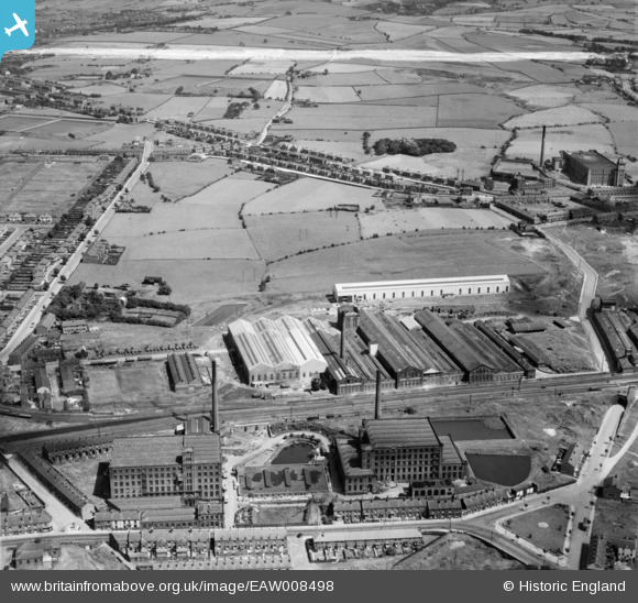
EAW008498 ENGLAND (1947). The Daniel Adamson and Co Engineering Works, Dukinfield, 1947. This image was marked by Aerofilms Ltd for photo editing.

© Hawlfraint cyfranwyr OpenStreetMap a thrwyddedwyd gan yr OpenStreetMap Foundation. 2024. Trwyddedir y gartograffeg fel CC BY-SA.

Delweddau cyfagos (39)

EAW008498
  0° 0m
EAW052647
  236° 34m
EAW037553
  328° 44m
EAW026615
  290° 52m
EAW037549
  246° 56m
EAW008502
  311° 60m
EAW037547
  250° 66m
EAW008499
  172° 67m
EAW037550
  247° 74m
EAW026614
  211° 87m
EAW026611
  210° 90m
EAW008501
  226° 93m
EAW052649
  264° 94m
EAW037545
  254° 98m
EAW026616
  239° 99m
EAW037554
  37° 99m
EAW037548
  209° 107m
EAW052646
  222° 109m
EAW037546
  253° 110m
EAW037544
  238° 111m
EAW026617
  211° 112m
EAW037551
  281° 118m
EAW026619
  220° 119m
EAW026621
  306° 120m
EAW026612
  7° 131m
EAW026618
  246° 131m
EAW026620
  208° 131m
EAW008500
  196° 133m
EAW037552
  233° 137m
EAW052648
  253° 145m
EAW052651
  82° 155m
EAW026613
  297° 202m
EAW052650
  45° 215m
EAW008497
  216° 217m
EAW008494
  201° 219m
EAW037555
  51° 223m
EAW008495
  235° 231m
EAW008496
  274° 245m
EAW052652
  39° 293m

Manylion

Pennawd [EAW008498] The Daniel Adamson and Co Engineering Works, Dukinfield, 1947. This image was marked by Aerofilms Ltd for photo editing.
Cyfeirnod EAW008498
Dyddiad 22-July-1947
Dolen
Enw lle DUKINFIELD
Plwyf
Ardal
Gwlad ENGLAND
Dwyreiniad / Gogleddiad 394547, 396694
Hydred / Lledred -2.0821506350185, 53.466704484511
Cyfeirnod Grid Cenedlaethol SJ945967

Pinnau

Pearson Street: a short dead end cinder covered street of two up and two down terraced houses. All had cold water, outside toilets and no bathrooms. Each house being heated by open coal fires, many still had gas lighting as was the case with the street lamps which were set on a tall ornate wrought iron posts which were lit each evening by lamp lighters. Children would often be seen gathering at the bottom of the street from where they could watch the express steam trains passing along the Manchester-Sheffield Line Information supplied by the Globe Lane Pals

Globe Lane Pals
Sunday 6th of July 2014 11:38:29 AM
Sand Shelter: This became a focus point for many local children to play, having been a former air raid shelter once covered with sandbags and which had rotted, resulting in a gigantic sand pit being formed for children to play in. Information supplied by the Globe Lane Pals

Globe Lane Pals
Sunday 6th of July 2014 11:15:06 AM
Stelfox's Off License: 116 Victoria Road. Home of Malcolm and Robert Stelfox ex-pupils of Globe Lane School. Information supplied by the Globe Lane Pals

Globe Lane Pals
Sunday 6th of July 2014 11:08:47 AM
New Inn: Located at the junction of Birch Lane and Dewsnap Lane. Information supplied by the Globe Lane Pals

Globe Lane Pals
Sunday 6th of July 2014 11:05:05 AM
Rising Moon Inn, Matley Lane: a well known stopping off place for Dukinfield children and their parents out walking along the many footpaths crossing the fields beyond Cheetham Hill Road. Information supplied by the Globe Lane Pals

Globe Lane Pals
Sunday 6th of July 2014 11:02:39 AM
Johnson Brook: old water course formed on the hill overlooking the districts of Shaw Hall and Yew Tree. Provided the power to many local mills, it gouged a valley off Newton Moor and down to Newton Wood before entering the River Tame. Later industrial development diverted the brook to become a feeder to the Peak Forrest Canal. The valley of the lower reaches, beyond the canal, was later used as the local corporation refuse tip. Information supplied by the Globe Lane Pals

Globe Lane Pals
Sunday 6th of July 2014 10:55:03 AM
Yew Tree Lane: This was once the starting point of our summer Sunday walks through the field over to Matley Lane and beyond calling at The Rising Moon for a drink of pop. Information supplied by the Globe Lane Pals

Globe Lane Pals
Sunday 6th of July 2014 10:45:04 AM
St Mary's Church, Shaw Hall Newton: many a former pupil of Victoria Road and Globe Lane Schools were married at this church. Information supplied by the Globe Lane Pals

Globe Lane Pals
Sunday 6th of July 2014 10:41:06 AM
Dransfield's Newsagents; This tiny triangular shaped shop was always busy being near to the railway station, bus stops and local industries. many a pupil from Victoria Road and Globe Lane School delivered newspapers for Dransfields were they would also buy their Dandy, Beano, Topper, Victor, Hotspur, Radio Fun, Eagle and other comics. The shop was also the local stockist for Standard Fireworks so we used to stand outside there with our stuffed Guy sat in an old pram. Information supplied by the Globe Lane Pals

Globe Lane Pals
Sunday 6th of July 2014 10:39:02 AM
Goodwin's Cake Shop: besides sell the best cakes around the shop was well known for the Grey Parrot which on sunny days was put out on its perch in the garden where it would shout aloud to passersby. Information supplied by the Globe Lane Pals

Globe Lane Pals
Sunday 6th of July 2014 10:30:55 AM
Remains of old coal tramway leading down from Victoria Pit to Newton Wood Canal Basin. Bridge under Victoria Road has been converted into air raid shelter but cutting still remains down to canal whilst Wood Street has been filled in. Information supplied by the Globe Lane Pals

Globe Lane Pals
Sunday 6th of July 2014 10:05:05 AM
Wood Street, once a cutting for old coal tramway now filled in after the building of railway cir 1850 Information supplied by the Globe Lane Pals

Globe Lane Pals
Sunday 6th of July 2014 10:04:34 AM
Old raised platform of former coal tramway; after the building of the railway (cir 1850) the old coal tramway which ran down from Victoria Pit to the canal basin, beyond Victoria Road, was diverted along this raised platform so that tubs of coal could be tipped into the waiting railway wagons. Prior to this deviation being built the tramway continued down an incline into a deep cutting, now Wood Street, before passing under Victoria Road and on to the canal basin beyond where barges were loaded with coal. Information supplied by the Globe Lane Pals

Globe Lane Pals
Sunday 6th of July 2014 10:03:52 AM
The shop at 82 Victoria Road was Sid Arnold's Grocery Shop; this was run by Sid and his daughter Valerie, both were former pupils of Victoria Road School and lived in a flat above the shop but later moved to 193 Dewsnap Lane. Information supplied by the Globe Lane Pals

Globe Lane Pals
Sunday 6th of July 2014 10:03:02 AM
90 Victoria Road: Braithwaites Clothing Outfitters Shop. The Braithwaite's were a local family originating from Edward Street, both Ernest and his son, John, attended Globe Lane School. Information supplied by the Globe Lane Pals

Globe Lane Pals
Sunday 6th of July 2014 10:01:53 AM
Former Victoria Road School 1870 to 1939 when pupils and teachers transferred to Globe Lane School. This building was later used as a canteen supplying meals to local schools. Now demolished and is the site of a car sales pitch. Information supplied by Globe Lane Pals

Globe Lane Pals
Sunday 6th of July 2014 09:40:28 AM

stardelta
Saturday 14th of June 2014 06:53:32 PM

stardelta
Saturday 14th of June 2014 06:52:35 PM
Victoria Mill

stardelta
Saturday 14th of June 2014 06:51:55 PM
128 Dewsnap Lane

lynningham
Thursday 20th of February 2014 11:34:42 PM