
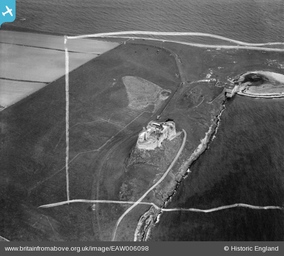
EAW006098 ENGLAND (1947). Lindisfarne Castle, Holy Island, 1947. This image was marked by Aerofilms Ltd for photo editing.
© Hawlfraint cyfranwyr OpenStreetMap a thrwyddedwyd gan yr OpenStreetMap Foundation. 2024. Trwyddedir y gartograffeg fel CC BY-SA.
Delweddau cyfagos (19)
EAW006098

EAW006099

EAW006100

EAW006102

EAW006101

EAW008899

EAW019696

EAW019697

EAW008050

EAW008900

EPW040696

EAW008897

EAW008898

EAW008896

EPW040695

EAW019694

EAW034341

EAW019695

EAW034340

Manylion
| Pennawd | [EAW006098] Lindisfarne Castle, Holy Island, 1947. This image was marked by Aerofilms Ltd for photo editing. |
| Cyfeirnod | EAW006098 |
| Dyddiad | 21-May-1947 |
| Dolen | |
| Enw lle | HOLY ISLAND |
| Plwyf | HOLY ISLAND |
| Ardal | |
| Gwlad | ENGLAND |
| Dwyreiniad / Gogleddiad | 413691, 641787 |
| Hydred / Lledred | -1.7823128629817, 55.669402328321 |
| Cyfeirnod Grid Cenedlaethol | NU137418 |
Pinnau
 melgibbs |
Friday 4th of November 2016 08:22:43 PM | |
melgibbs |
Saturday 14th of December 2013 04:05:30 PM | |
melgibbs |
Saturday 14th of December 2013 04:04:36 PM | |
Originally a tramway by which limestone was brought down the eastern side of the island to limekilns immediately east of the castle. The kilns' quicklime output was exported (mainly to Scotland) during the 1870s and 1880s from jetties just west of the castle. In the 1850s and 1860s a similar system had operated on the western side of the island, exporting the quicklime via a jetty west of the village. |
 DaveH |
Sunday 12th of June 2016 10:54:22 PM |
melgibbs |
Saturday 14th of December 2013 04:04:14 PM |


