
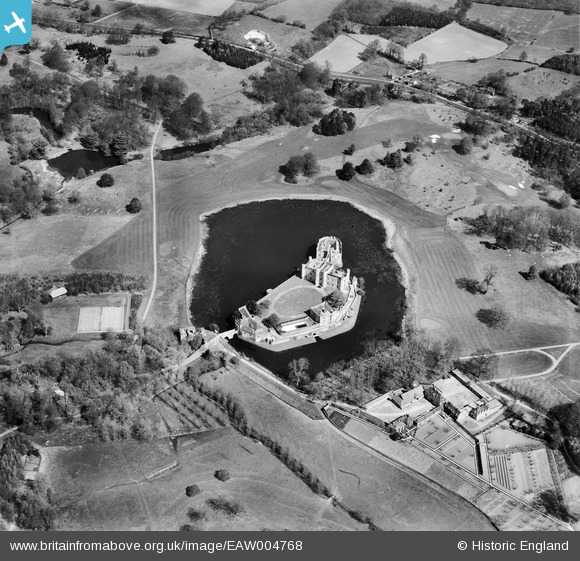
EAW004768 ENGLAND (1947). Leeds Castle, Broomfield, 1947
© Hawlfraint cyfranwyr OpenStreetMap a thrwyddedwyd gan yr OpenStreetMap Foundation. 2024. Trwyddedir y gartograffeg fel CC BY-SA.
Delweddau cyfagos (18)
EAW004768

EAW013653

EPW009216

EAW017623

EAW004772

EPW009215

EPW018638

EAW004769

EAW013654

EPW038119

EPW038114

EPW038116

EAW013657

EAW004771

EAW004770

EAW013656

EAW013655

EAW004767

Manylion
| Pennawd | [EAW004768] Leeds Castle, Broomfield, 1947 |
| Cyfeirnod | EAW004768 |
| Dyddiad | April-1947 |
| Dolen | |
| Enw lle | BROOMFIELD |
| Plwyf | BROOMFIELD AND KINGSWOOD |
| Ardal | |
| Gwlad | ENGLAND |
| Dwyreiniad / Gogleddiad | 583625, 153296 |
| Hydred / Lledred | 0.63141699368569, 51.248716988269 |
| Cyfeirnod Grid Cenedlaethol | TQ836533 |
Pinnau
 totoro |
Sunday 20th of October 2013 10:25:26 AM | |
totoro |
Sunday 20th of October 2013 10:24:23 AM | |
totoro |
Sunday 20th of October 2013 10:08:23 AM | |
totoro |
Sunday 20th of October 2013 10:08:00 AM | |
totoro |
Sunday 20th of October 2013 09:58:06 AM |
Cyfraniadau Grŵp
 2004 view |
totoro |
Saturday 19th of October 2013 05:21:51 PM |


