
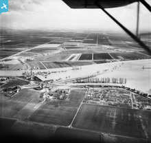
EAW003833 ENGLAND (1947). Flooding of the River Great Ouse near Littleport Railway Station, Littleport, from the west, 1947

© Hawlfraint cyfranwyr OpenStreetMap a thrwyddedwyd gan yr OpenStreetMap Foundation. 2024. Trwyddedir y gartograffeg fel CC BY-SA.
Manylion
| Pennawd | [EAW003833] Flooding of the River Great Ouse near Littleport Railway Station, Littleport, from the west, 1947 |
| Cyfeirnod | EAW003833 |
| Dyddiad | March-1947 |
| Dolen | |
| Enw lle | LITTLEPORT |
| Plwyf | LITTLEPORT |
| Ardal | |
| Gwlad | ENGLAND |
| Dwyreiniad / Gogleddiad | 557278, 287296 |
| Hydred / Lledred | 0.31520928294903, 52.46055694847 |
| Cyfeirnod Grid Cenedlaethol | TL573873 |
Pinnau
 Matt Aldred edob.mattaldred.com |
Monday 8th of March 2021 08:33:24 PM | |
Matt Aldred edob.mattaldred.com |
Monday 8th of March 2021 08:27:40 PM | |
Matt Aldred edob.mattaldred.com |
Monday 2nd of September 2019 03:14:51 PM | |
 jrussill |
Friday 24th of July 2015 12:38:49 PM |
Cyfraniadau Grŵp
 WW2 Pillbox |
jrussill |
Friday 24th of July 2015 12:42:26 PM |


