
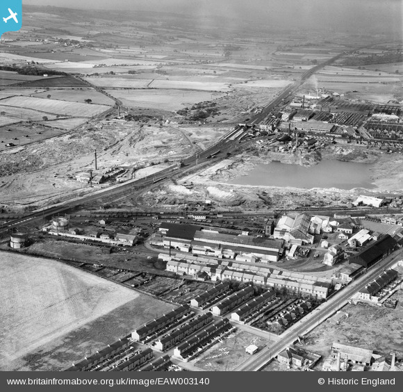
EAW003140 ENGLAND (1946). The Birtley Iron Co Ltd Works and the surrounding area, Birtley, from the south-east, 1946
© Hawlfraint cyfranwyr OpenStreetMap a thrwyddedwyd gan yr OpenStreetMap Foundation. 2024. Trwyddedir y gartograffeg fel CC BY-SA.
Delweddau cyfagos (13)
EAW003140

EAW003139

EAW003146

EAW003149

EAW003145

EAW003143

EAW003147

EAW003144

EAW003142

EAW003148

EAW003141

EAW003138

EAW003136

Manylion
| Pennawd | [EAW003140] The Birtley Iron Co Ltd Works and the surrounding area, Birtley, from the south-east, 1946 |
| Cyfeirnod | EAW003140 |
| Dyddiad | 23-October-1946 |
| Dolen | |
| Enw lle | BIRTLEY |
| Plwyf | |
| Ardal | |
| Gwlad | ENGLAND |
| Dwyreiniad / Gogleddiad | 427146, 555003 |
| Hydred / Lledred | -1.576760927976, 54.888947209211 |
| Cyfeirnod Grid Cenedlaethol | NZ271550 |
Pinnau
 Matt Aldred edob.mattaldred.com |
Monday 8th of March 2021 06:37:29 PM | |
 Stuart |
Tuesday 10th of September 2013 02:41:40 PM | |
Stuart |
Tuesday 10th of September 2013 02:40:47 PM | |
Stuart |
Tuesday 10th of September 2013 02:40:21 PM |


